

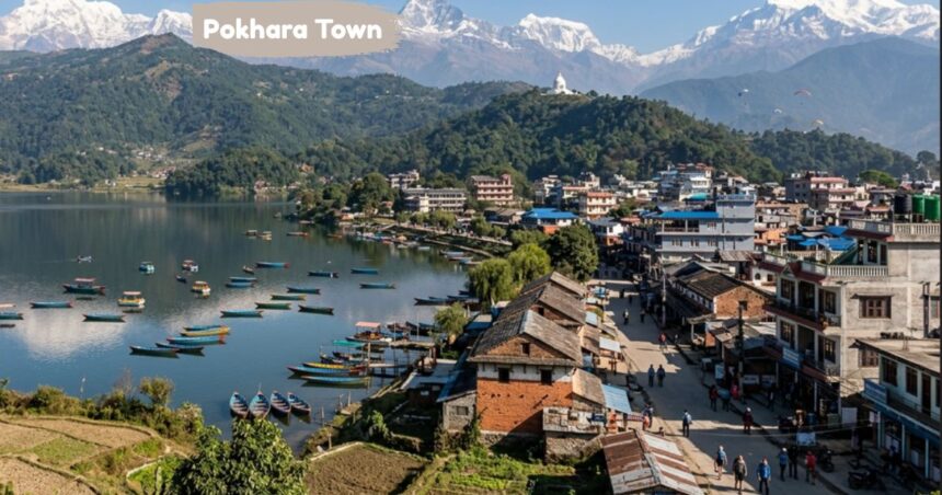
Sitting quietly near Fewa Lake about 200 km from Kathmandu in Gandaki Province, Pokhara Town is Nepal’s famous mountain getaway. The aerial distance to the Himalayan peaks of the Annapurna mountain range is only 15–30 km, so Annapurna I, Dhaulagiri, and Manaslu rise right behind the area like a painted backdrop. Located in Kaski district, you can reach this destination via a 20-minute flight or a 7-hour drive through lush green forests, rolling landscapes, and village scenery.
Key Demographics, Gateway Status & Lakes of Pokhara Town
The 2021 census counted 513,504 residents across the metropolitan area, yet life in Pokhara Town feels calm compared to larger metropolises because the community stays closely tied to nature and trekking culture. Often called the city of 7 lakes due to Begnas Lake, Rupa Lake, Khaste, and Kamal Pokhari surrounding Phewa Lake, it serves as the primary gateway for the Annapurna Circuit with clear views of Machhapuchhre and Dhaulagiri (the 7th highest peak at 8,167 m).
On a quiet morning at Sarangkot in Ward 18, visitors catch world-class sunrise views over the valley. From this central hub, travelers pursue adventures like paragliding, boating, bungee jumping, hiking, and ziplining. Near Davis Falls, Gupteshwor Mahadev Cave ranks among the longest caves in Nepal, while the pagoda-style Tal Barahi Temple sits on a small island in the middle of Phewa Lake.
Historical Trade and Cultural Foundations
Walking along the lakeside streets, you pass cafés, bookstores, yoga studios, and small bars filled with trekkers and backpackers, creating the bohemian vibe that earned the area its status as Nepal’s tourism capital. This rich culture grew from a layered past when the valley served as a vibrant trade route between India and Tibet, moving salt, wool, and mountain goods via caravans.
Ethnic Diversity and Community Life
Communities like the Gurungs, Magars, and Thakalis settled here centuries ago, shaping local mountain traditions around trade. By the mid-20th century, mountaineers exploring the Annapurna Circuit brought a new wave of visitors, followed by travelers in the 1960s and 1970s who established the region’s easygoing spirit. Today, Gurung, Magar, and Thakali customs blend alongside Chhetri, Brahmin, Newar, and Tamang traditions. Hinduism and Buddhism remain dominant, while distinct Tibetan refugee settlements preserve traditional folk dances, music, and crafts.
Transport & Getting to Pokhara Town
Reaching Pokhara Town from Kathmandu is straightforward. Tourist buses and local transport depart daily near Thamel, taking roughly 6–9 hours depending on road conditions. A private vehicle or jeep reduces the drive to 6–7 hours, providing flexibility for stopovers while enjoying mountain views and rolling green landscapes along the route.
Flights and Local Transit Options
For faster travel, domestic flights land at the local airport in just 25–30 minutes from Kathmandu. Once in the valley, walking covers most Lakeside hotels, cafés, and restaurants. Local micros and minibuses connect the wider area for around NPR 100–400 (£0.50–£2.00 / US$0.70–$2.70), while standard scooter and bicycle rentals offer convenient options for exploring surrounding hills.
Traditional Nepali Flavors
Local kitchens lean on lentils, rice, barley, corn, and stewed meats. The primary daily staple, Dal bhat, pairs steamed rice (bhat) with spiced lentil soup (dal), seasonal vegetable curries, pickles (achar), and fresh yogurt.
Street Food and Regional Delicacies
Street stalls offer momos (steamed or fried dumplings with spiced meat or vegetables), thukpa (a hearty noodle soup), and chau chau (fried noodles). Visitors can also try traditional Thakali Thali sets, sel roti, dhindo, gundruk, and local rice wine (chhang).
Things to Do and Regional Attractions
Most visits center around Pokhara Lakeside (Baidam), located along the eastern shore of Phewa Lake. The area features a long strip of restaurants, craft shops, and bars, serving as the main staging point for wooden boat rentals, kayaking, and paddleboarding under the mountain backdrop.
Pagodas, Caves, and Mountain Trails
The World Peace Pagoda (Shanti Stupa) sits atop a ridge overlooking the lake, offering panoramic views of the range. Sarangkot provides a launching pad for paragliding and early morning sunrise tours, while the International Mountain Museum documents the history, geology, and mountaineering achievements across the Himalayas.
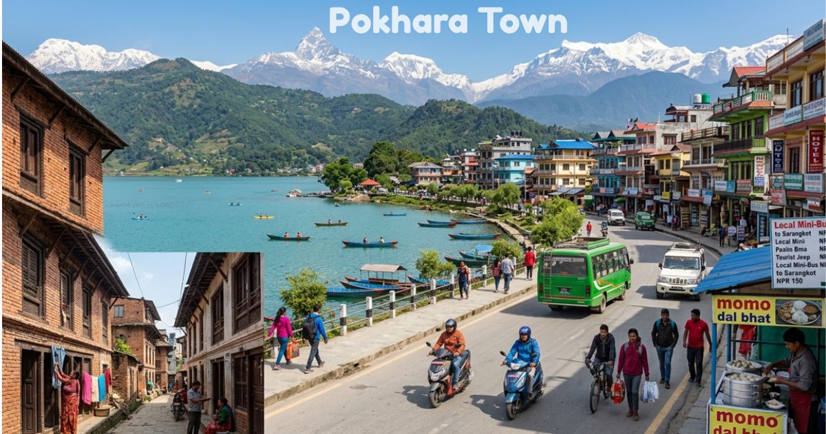
Urban Landscape and Daily Life
The visual character of Pokhara Town combines modern hospitality infrastructure with traditional Himalayan neighborhoods. Contemporary hotels and guesthouses line the tourist zones, while traditional bazaar areas feature classic brick buildings, narrow alleyways, and vibrant local markets.
Community Spirit
Moving past the primary tourist strips reveals authentic domestic life. Older residential districts preserve traditional Nepalese architecture, showcasing the balance between a bustling international adventure hub and a grounded mountain community.
Money, Costs, and Travel Budgeting
Transactions run on the Nepalese Rupee (NPR). While major hotels accept credit cards, smaller eateries, markets, and local transport operate strictly on cash. ATMs accepting Visa and Mastercard are widely available throughout the Lakeside area.
Average Expenses
- Daily Budget: NPR 3,300 (£17.00 / US$23.00) for mid-range daily expenses.
- Accommodation: NPR 1,000–3,000/night (£5.00–£16.00 / US$7.00–$21.00) for budget guesthouses; mid-range and luxury stays start above NPR 4,000.
- Meals: Street food starts around NPR 100, while sit-down meals range from NPR 200 to 800 (£1.00–£4.00 / US$1.40–$5.50).
History, Mapping, and Regional Geography
The name derives from Pokhari, the Nepali word for pond or lake. Historical records trace permanent settlements back to the 14th century when the King of Kaski used the valley as a winter capital. By the 17th century, it joined the Chaubise kingdom, evolving into an essential trade hub linking India and Tibet.
Modern Mapping and Open Data in Pokhara Town
Urban development and disaster preparedness initiatives have driven mapping projects across the valley to better protect Pokhara Town. Collaborations with organizations like Kathmandu Living Labs (KLL) utilize OpenStreetMap data to improve infrastructure planning and emergency resilience, ensuring the safety of both residents and visitors exploring popular regional treks like Ghorepani Poon Hill, Ghandruk, and Dhampus.
Frequently Asked Questions
How do I read and navigate a Pokhara Town map?
Lakeside layout: A standard spatial map highlights the primary coastal zone running parallel to Fewa Lake, housing most traveler amenities.
Topographic clarity: The cartographic layout features clear routes leading northward toward the alpine footpaths of the Annapurna region.
What is Pokhara famous for?
Adventure center: Known worldwide as a thrill-seeking hub, it draws travelers for paragliding journeys, lakeside rowing, and panoramic mountain views.
Himalayan gateway: It serves as the primary expedition base for iconic alpine trekking trails.
Which state and district is Pokhara located in?
Provincial status: Pokhara acts as the vibrant provincial capital of Gandaki Province.
District border: It is situated directly inside the Kaski District region of western Nepal.
What about the weather?
Seasonal shifts: Enjoys a subtropical environment with clear autumn skies, mild winter days, and heavy monsoon precipitation during mid-year months.
Best timing: Spring and autumn offer crisp atmospheric visibility and optimal seasonal temperatures for trekking.
What are the top places to visit around Pokhara Town?
Scenic landmarks: Popular tourist destinations include Phewa Lake, Begnas Lake, and Davis Falls.
Elevated viewpoints: Sites like the World Peace Pagoda and Sarangkot offer panoramic vistas of the Annapurna range.